AT: Bearwallow Gap (VA-43) to Troutville (US-11)

This past weekend Maple and I continued our southward journey on the AT in Virginia, hiking 20.1 miles, beginning at VA-43, east of Buchanan, and ending in the town of Troutville. Once again, we relied upon a shuttle service provided by Homer Witcher, who is the supervisor of all the shelters under the care of the Roanoke A.T.C. He dropped us off at our beginning point at 10 a.m. on a beautiful, but cold, Saturday morning. The temperature reached up into the 40s in the late afternoon, but with the constant wind, it rarely seemed much above freezing. A beautiful day for hiking, if dressed appropriately. And we were.

We crossed the Blue Ridge Parkway several times on Saturday, and the trail stayed fairly close to it always, until we reached Taylor Mountain Overlook. Here, after having our lunch, we crossed the parkway one last time, westward, and then parted ways with it. From here it was another 2.8 miles to Wilson Creek Shelter, where we were to spend the night.

Our water source.

We knew that Wilson Creek, an abundant water source, was a half mile south of the shelter, and since we weren’t looking forward to adding a mile to our hike (back and forth from the shelter), we took advantage of what appeared to be a small spring that crossed the trail about a quarter mile north of our destination. We filled our dromedary, continued our hike, and arrived at Wilson Creek Shelter before 4 p.m.

Seven young people had arrived before us. Among them were four north-bound thru-hikers, the first that we have come across this year: Hot Rod, Alpine, Sub-Zero, and his partner, Golightly. They had begun their journey in January and were presently accompanied by several college friends on spring break from Illinois–friends who were getting a taste of the backpacking life. At dusk, Maple accepted their invitation to make smores. They were all quite friendly, and it was a real pleasure to get acquainted with them. My only real concern is for Alpine, who has made it a habit to hike at night using his headlamp. Already he has had several falls, and I fear that it is only a matter of time before he injures himself.

Maple and I retired with the sun, played a game of backgammon, and then slept well, bundled up in our long underwear and sleeping bags with liners. When the Sunday morning sun woke us up, we made our breakfast of oatmeal and coffee on the picnic table in front of the shelter. When we packed up, we forgot our sporks on the table. It was an oversight we wouldn’t discover until we stopped for lunch at Fullhardt Knob Shelter. Eating Lipton’s Cup-a-Soup noodles with our fingers reminded us of our dinner along the “Roller Coaster” in northern Virginia, when I had forgotten to pack our sporks, and we had to manage macaroni and cheese with our fingers.

Fullhardt Knob Shelter

Fullhardt Knob Shelter has a cistern from which we were able to filter water. We had planned to spend Sunday night here, but we had made good time, despite the thousand-foot elevation gain between Curry Creek and Fullhardt Knob. And, since we didn’t have sporks with which to eat dinner and breakfast, we decided to hike the remaining 3.8 miles to our parked car on US-11.  Interestingly, after descending from the shelter, we had to pass through some privately owned land, including a cow pasture and a grass covered hillside, which is very steep and not represented on the AT map.


AT: Sunset Field (Blue Ridge Parkway) to VA-43

Oh, how hard it is to be off the trail for such a long time! This hike was a long time coming. We first attempted this stretch on December 30th, 2016. Unfortunately, a trace of early morning snow was enough to completely ice over VA-43, making the drive to our destination impossible. So close and yet so far! The hike would have to wait.

On February 11, 2017  Birch and I were shuttled from VA-43 to Sunset Field by Mr. Homer Witcher, an inspiring guy who thru hiked the AT with his family in 2002. Mr. Witcher is a model example of what makes the AT so special. He maintains large portions of the trail, is an expert privy builder, and is kind enough to shuttle folks to trailheads. He gives tons of his time to the AT. (Thank you!)

2-12_1329
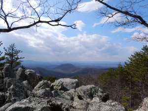
The hike from Sunset Field to Bryant Ridge Shelter was fairly easy. The bare trees gave us opportunities to view the mountains. After reaching Floyd mountain the next three miles were  steep and downhill. My legs were killing me!

We stayed the night at Bryant Ridge, an amazing shelter. It has three stories, with a very large, covered area to just hang out. Water is plentiful. The only downside is that we didn’t find any great spots to set up our tent. I guess with a large shelter, most wouldn’t use a tent anyway.

Lucky for us, we were not alone. Two guys, “Roub” and “Crackin” soon came into camp. Both are expert AT hikers. Roub completed a thru hike and Crackin thru hiked Virginia. We learned a lot of great tips from them. As important, they were just great company.

The next day Birch and I went about 7 miles to Cove Mountain Shelter. Roub and Crackin advised us against carrying water up Fork Mountain, and we were so glad that we took their advice. We loaded up with water at Jenny Creek, four miles into the hike, then went up, up, up until we reached the shelter. We were excited to read the trail log and see a note from our new trail friends. The trail magic was a special treat!

Sunday evening, we decided to skip the tent and stay in the shelter. Luckily, we were well prepared. We brought winter jackets, sleeping bag liners, and other cold weather gear. The temps went from the 70’s to 30 degrees by morning time. Boy, the wind howled and  roared! 2-12_1422

The hike out was beautiful, despite the cold temps. The ridge is lined with pretty green moss, making us ALMOST forget that it was still winter.


(Follow Roub’s adventures at: trailjournals.com/Roubaix)

AT: US-501/VA-130 (James River) to Sunset Field, Blue Ridge Parkway

This was the last autumn backpacking venture that Maple and I would have for the year, and (as it turned out) it was also our first hike for the winter of ’16/17, for winter surely descended upon us on Saturday, November 19. But I am getting ahead of myself.

11-18_1532Maple did some preparatory research for our backpacking trip and was told that a dry season had left Marble Spring spent, and that we should expect no available water at Marble Spring Campsite. So, in addition to packing our usual water for the hike, I filled my 4-litre dromedary. Unfortunately, on the way to our beginning point, one of my Camelback bottles leaked, and I found it to be completely empty as I prepared to begin our hike. The situation placed Maple and I in a quandary, but just then a mobile home pulled into the parking lot. I asked the driver if he had any water to spare, and his wife happily refilled my bottle. Afterwards I found that they were there with the intent to be of service to hikers—that they were, in fact, traveling trail angels.

Our hike began by crossing the James River on the longest footbridge on the entire A.T., and then walking westward alongside it for nearly a mile, until we reached Matts Creek. 11-18_093711-18_0938Then we followed the creek to Matts Creek Shelter before crossing it and beginning our ascent up to Hickory Stand. There Maple and I took a break for lunch, and proceeded about a mile before running into two trail workers, Buckeye and Grateful, with the Natural Bridge Appalachian Trail Club. They invited us to sit with them a bit, and we learned that they were also section hikers.

11-18_105111-18_1127

At 7.8 miles we reached Marble Spring Campsite and found that no one else was there. 11-18_1531The first order of business was to check the spring, just in case, and we found that it was producing a steady but slow current. Once again, caution had prompted me to carry a heavy load of water unnecessarily. Still, better to be cautious than sorry. After setting up our tent and enjoying a cup of coffee, first a young woman (Grizzly) and, later, an older man (Leprechaun) strolled into camp. They both had the “gift of gab” and proved sufficient company for one another, so Maple and I called it an early night. During the night another southbound backpacker (who had sent home his tent!) came into camp.

It had been a warm day, reaching sixty-nine degrees, and the night was cloudless and comfortable. But the following day, during the late morning and early afternoon, the temperature dropped thirty degrees, and a powerful wind came into play, knocking down branches and scattering a fresh layer of leaves over our trail. In addition, dark clouds blew over us, threatening rain. Although Maple and I had 9.5 miles to hike, most of it uphill, we took few and short breaks, as we were afraid we were going to get pelted by freezing rain. Fortunately, we stayed dry and the clouds were blown away in the early afternoon.

11-19_1135

Thunder Hill Lookout

The Guillotine

The Guillotine

We passed Thunder Hill Shelter without visiting it, nor did we spend any time at the lookout on top of Thunder Hill. But we did pause briefly at the Guillotine. Who would not pause before walking under a boulder supported by two granite walls? That boulder may have been where it is for centuries, but it nevertheless looks like it is waiting to fall—just like the blade of a guillotine.

AT: US-60 to US-501/VA-130

Day One: US-60 to Mile 51.7, Blue Ridge Parkway

Having a long day of hiking ahead of us, Maple and I wanted to get on the trail rather early in the day, so we spent the night before at a hotel close to Liberty University in Lynchburgh. We saw plenty of “Vote for Trump” signs and not a single sign in favor of Hillary Clinton. We were definitely deep into central Virginia.

Usually, the beginning of a hike takes us out of a gap and up a mountain or steep incline to a ridge, but this was an exception. A smooth and easy trail, covered in autumn leaves, followed Brown Mountain Creek for nearly two miles. At Brown Mountain Creek Shelter we spotted a couple of backpackers, who appeared to be just beginning their day. Just beyond the shelter is a footbridge over the creek. A mile further we crossed the second footbridge, near a swimming hole, and then left the creek behind us.

10-28-093010-28-111110-28-0951

The trail takes the long way around Lynchburgh Reservoir, but neither of us were complaining, as the trail afforded several nice views through the trees of the artificial lake and damn. Walking around several gullies reminded Maple of hiking the Tonto Trail in the Grand Canyon, where one has to walk around side canyons and creeks.

After circling around Lynchburgh Reservoir, at about the 6.5 mile point, we crossed the suspension bridge over Pedlar River and, then, began our 1200-foot ascent of Rice Mountain. The trail was still technically easy, but the mountain was the most difficult part of the day’s hike. While hiking up the mountain we came across two other hikers, the only ones we saw on the trail this day.

10-28-113510-28-1136

All-in-all, it was a pleasant day-hike of 10.9 miles. The trail itself was about as easy as one can find on a ten-mile stretch of the A.T., and the fall foliage and cool weather made for beautiful scenery and comfortable hiking.

Day Two: Blue Ridge Parkway to US-501

After a great hike the previous day, Birch and I were really looking forward to this hike. We, were wimps, I admit, and stayed overnight in a hotel. We needed to go over 10 miles and still have time to get home (5 hour drive) so going without all the backpacking gear seemed the best bet.

The hike began with a sharp ascent of about two miles. At the .4 mile mark we saw the turn off to Punchbowl Shelter. Punchbowl Mountain was not too impressive since there were no overlooks. We barely knew we had reached the summit. About a mile later we reached the top of Bluff Mountain and this had an amazing panoramic view of the Shenandoah Valley.

10-29-105610-29-1006

We had a one-mile descent and then things leveled off as we passed Saltlog Gap. There we saw one person camping. It was a pretty quiet day on the trail, considering that it was a Saturday with unusually warm weather.

10-29-1300We stopped for coffee just before Big Rocky Row and 10-29-1301then came to Fullers Rocks overlook. It was the perfect spot to take in the view, eat a sandwich, and rest in the sun. As we made the – descent we began seeing other folks going up the trail for a day hike. This included a rather rambunctious group of boy scouts (maybe 20?) all excited to be on the trail.

The last part of the hike is really beautiful. We walked along a beautiful stream and were able to enjoy a bit of serenity before having to make our way back home. Birch liked this hike better than yesterday but both are great day hikes.

10-29-1457


Appalachian Trail: VA-56 (Wye River) to US-60

9-23-842Day One: VA-56 to The Priest Shelter

Maple and I stayed at the Amherst Inn on Wednesday night, so we could get off to an early start Thursday morning. The weather was perfect. In the upper 70s, with clear skies. What we were more concerned about was the availability of water on top of The Priest. Maple and I had both made inquiries, and what we were told left us thinking that, to be sure of water, we had to carry it with us. (Thanks Natural Bridge Appalachian Trail Club!) So I packed on an extra 4 liters, and Maple carried an extra 1.75. That, plus four days of food and clothing, made us feel that we were carrying the heaviest packs ever.

We had seen The Priest mountain before, when descending to VA-56 through the Three Ridges Wilderness one month ago. It was an imposing sight, with a peak stretching upwards through a canopy of clouds. “That is what we have to climb on our next outing?!” we said, with no little anxiety. Yet, we did it. One step at a time. Having experienced a rather calamitous fall during that former backpacking venture, I was especially careful to keep my eyes on the ground before me, so as not to get tripped up. Maple and I made a game of counting the switchbacks: roughly, 35. (What counts and does not count as a switchback is a consideration that will lead to varying results.)

9-22-1010

We stopped to have lunch on some rocks about two-thirds of the way up, at an overlook, and took pictures. A little snake seemed to take an interest in us, and came so close that it peeked up at us from under Maple’s backpack. She screamed and sent the critter scrambling under leaves. From here on the hike seemed to get more difficult. Ultimately, we were pausing every ten to twenty yards to catch our breath. Finally, we reached the top, where, over the rocks to our right, 9-22-1351was the last overlook. Maple insisted I check it out, and since it was level ground, I consented. But, I got careless, and my boot got caught on a root, sending me diving face-first into the dirt. In the presence of The Priest, I cursed. I confess I was pissed off at myself, since I had tried so hard to be careful before taking this short detour.

F9-22-1657inally, we arrived at The Priest Shelter. There, we found that we had carried the extra water unnecessarily, that the spring was flowing, however so gently. We set up our camp, made coffee, filtered water, and relaxed. After making dinner, we played a game of backgammon, retired, and day one was over.


Day Two: The Priest Shelter to Seeley-Woodsworth Shelter

Day two was expected to be an easy, 6.7 mile jaunt. This area was once a logging area, and much of the larger trees were wiped out in the 1930s or so. It did seem like there was more new growth than some areas we’ve hiked before. However, it was beautiful. It was far enough away from main roads to be very quiet and peaceful.

9-23-842The trail descended sharply going south from the Priest. Then, it offered a series of ascents and descents (overall going up about 1,000 ft.) before reading “Spy Rock”. Spy Rock is a very popular day hike. It was fun to see people ooh and aw over our “big” backs. “You are obviously professionals,” someone said. Yeah. Right.

We had lunch at Spy Rock but never did get to the top. I’m sure it must be possible but it required a bit too much effort for our liking. Apparently, this was once a great place for the Confederate troops to track the forces from the North. I’ll have to take others’ word for it.

In about 2 1/2 miles we reached Seeley-Woodsworth Shelter. It has a tremendous, well-running spring that enabled us to fill up to our heart’s content with water. There, we met “Star Man” and “Fire Starter”, two brothers who valued fellowship over tough hikes. They had skipped the Priest but had experienced other fun adventures on the trail. A surfer/massage therapist/Costa Rican named Todd joined us at the shelter and we had a blast sharing stories. Overall, it was a wonderful day.

Home Sweet Home at Seeley!

Home Sweet Home at Seeley!

Day Three: Seeley-Woodsworth Shelter to Cow Camp Gap Shelter

Day three was, potentially, our hardest venture, with 10.2 miles to hike to get to the blue trail leading to the shelter—another .5 miles. It was the furthest we had ever committed ourselves to hiking with full backpacks. Having been previously informed that the spring at Cow Camp Gap was dry, we stashed a water supply off the trail at a clearing two miles north of Cow Camp Gap. So, at least we didn’t have to carry extra water as far as this clearing.dscn0631

The hiking wasn’t too difficult, and we arrived at Hog Camp Gap at about noon. There we rested under apple trees, had an apple with our lunch, and were about to begin our descent up Cole Mountain when I suddenly realized that this was the place that I had stashed water. I hadn’t known exactly where I had stashed water, only that there was a sign indicating that it was two miles before Cow Camp Gap. When I saw the sign, I realized that Hog Camp Gap was the place. So, we retrieved our water, and with the added weight, climbed Cole Mountain.

On our ascent, we encountered a woman with a melodious southern ascent who assured 9-24-1326us that Cole Mountain rewarded its climbers—that it was like that hill that Julie Andrews climbed in The Sound of Music that inspired her to break out in song. Well, Cole Mountain did, indeed, have a wonderful panoramic view (not quite 360 degrees, but still rather impressive for a hill—not quite as majestic as The Priest). We did not sing, not that we did not want to—perhaps, we were out of breath. A little ways south, we encountered a father and son team who volunteered to take our picture.

9-24-1122b

Finally, we arrived at Cow Camp Gap Shelter and discovered that the spring was flowing. Once again, we had carried extra water unnecessarily. The good thing about it was that we had no need to filter water. We had plenty of water to spare. As there was a small family inhabiting the shelter and playing their music, we decided to hike further down the creek. There we found good tent spots and quiet. Todd, the surfer dude that we had met at Seeley-Woodworth, had made it here before us, but there was ample space, and Todd hardly made his presence known.

Day Four: Cow Camp Gap Shelter to US-60

Our campsite.

Our campsite.

We awoke in the middle of the night to rain. By morning, everything was soaked, especially (for some reason) the inside of our tent. Birch was kind enough to get up and make coffee. After warming up with the cup ‘o Joe, we decided that the best thing to do was to eat a power bar and get moving. We packed up quickly and put on a bit of rain gear. However, by the time we went the 1/2 mile back up to the AT we decided that wearing the rain gear wasn’t worth it. We were too hot!

The fresh, cool, rainy weather was just what we needed to ascend the 2 miles to the top of Bald Knob. There are no overlooks here, which is just as well since we were fogged in. The descent is long (over two miles) and steep (a 2000 ft descent.) We made great time and were back to the car well before noon. US-60 has plenty of parking and the wayside was full of cars, many with AT bumper stickers. I guess it is a popular spot. I can’t wait to get back here for our next adventure, as we continue south on the trail.

Appalachian Trail: Dripping Rock to Route 56 ( and lessons in first aid!)

After finishing off the AT in Shenandoah National Park, Birch and I were able to jump back to our southern most point in the trail, at Dripping Rock. Our plan was for an uneventful two day backpacking trip with a stay at Maupin Shelter. This area is known as the Three Ridges.

On the map, this looks like a piece of cake. In fact, the first six miles are fairly flat. The heat was a bit of a challenge, and by the time we got to the shelter it was about 1:00 pm. DSCN0593We ate lunch, filled our bottles with water, and debated our next move. It seemed a bit early to stop hiking. Should we stay at the shelter or move on? Looming on the horizon was the threat of major thunderstorms the next day. The last thing I wanted to do was a 9 mile hike in bad weather (especially the upcoming 3 mile ascent to a mountain peak – possibly during a thunder storm.)  We continued our hike, thinking that if we can at least get over the next peak, we’ll be that much closer to completing our trip before the storms get the best of us.DSCN0588

Theoretically, this was a good idea. Practically, it was a huge mistake. The big ascent, after already backpacking six miles, got the best of us. Birch was definitely suffering from heat exhaustion. We ALMOST decided to camp on the peak. But after a rest, Birch was feeling better and we felt that getting to the next shelter was doable.

About a half mile into our descent, near the middle ridge, Birch slipped on loose rocks, lost his balance, and tumbled down an embankment for about 20 feet. He was stopped by his arm getting caught in a tree limb. He suffered significant gashes to his head, a gash on his nose bridge, black eye, a big cut on his leg, and abrasions everywhere. His glasses? Lost! Talk about scary! The first aid kit was not well supplied, but we did the best we could to stop the bleeding and clean the wounds. Getting off the mountain that night was not an option. We were tired and it was getting dark.

We camped on the side of the trail overnight and I kept watch for any signs of confusion, etc. The next morning, we slowly descended a very rocky, difficult section of the trail and came to the  shelter. We used the stream water (filtered) to further clean wounds. Then, we  ascended a small hill before descending down a very steep area for about another two miles.

A tough trail!

A tough trail!

In the end, Birch got to the emergency room and was stitched up. Did you know that there is only a 24 hour window before stitching is not an option? We barely made that window! He definitely had a concussion so we were very fortunate that things turned out ok. The lesson? Don’t skimp on the first aid kit! I’m going to add a small squirt bottle that makes it easier to clean wounds. In a really bad situation, those little alcohol swabs don’t cut it (no pun intended). Make sure you have phone numbers for emergency assistance – just in case.


Tod looking great at the beginning of the hike

Birch looking great at the beginning of the hike

On the mountain after the accident.

On the mountain after the accident.