Scott’s Run Nature Preserve

Yesterday afternoon Maple and I participated in an L. L. Bean-sponsored, three-mile hike at Scott’s Run Nature Preserve— just off of Georgetown Pike, on the Virginia side of the Potomac River. As an employee of L. L. Bean and prospective hike leader, I was there, for the first time, not just to participate, but also to observe and take notes. David Manco, the Coordinator of Bean’s Outdoor Discovery School Program at Tyson’s Corner, in McLean, Virginia, was introducing and leading the hike. Maple had been here to hike once before, five years previously.

From the lower and larger parking area off of Georgetown Pike, we took the dark blue trail north to the Potomac River and to the modest falls, where Scott’s Run enters the Potomac. From there, we skirted the Potomac going east on the light blue trail finally climbing to an overlook. There we took a brief break, before getting onto the yellow trail that leads south through the center of the park, under the canopy of trees and terminates at the upper and smaller parking area. From there, we took the purple trail paralleling Georgetown Pike and ending back at the lower parking area. Looking at a map of the area, one can see that our path formed what might roughly be described as a square.

The participants in this hike were Maple and myself, a couple of middle-aged women friends, and an Asian husband and wife, with their thirteen-year-old son, along with our leader, David, and his wife, Linda.


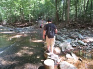
There was an ankle-deep stream that we had to cross twice. Both times, concrete stepping stones were in place to facilitate a dry crossing. These stepping stones were close together, so that a child could cross. Perhaps they were too close together, for two of our participants fell while crossing and skinned their shins. Caution is evidently needed here.

Our small group judged this hike to be of intermediate difficulty, since the light blue trail involved a little scrambling. The highlight of the hike, at least for me, was the easy yellow trail, which passes directly through the middle of the park, under a canopy of trees.
AT: NY-55 to Hoyt Rd.

Birch and I were excited to get back on the trail this Labor Day weekend. A trail volunteer named Donna picked us up at the Hoyt Rd. parking area and gave us a ride to the trailhead. While traveling, we learned that Donna is an amazing volunteer. She is someone who actually supervises volunteers and is active in the work of the Appalachian Trail Conservancy. She also volunteers for Hike for Mental Health (https://www.hikeformentalhealth.org).

The weather couldn’t have been better. It was cool (in the 70s) with just a hint of a breeze. The beautiful weather was matched by a beautiful woodland. The lack of elevations made for quick hiking, but we immediately noticed that water was going to be an issue. Each of the water sources that were marked on our map as being “plentiful” were, in fact, bone dry. Thus, when we found a low water source we took advantage of it and filled our dromedary, even though we were only a couple of miles into our hike. This proved to be a very good decision.

Birch and I approached this hike as a casual one so we built in plenty of time to just enjoy camping. We stopped at the Telephone Pioneers Shelter, just four miles into our hike. The hike to the shelter was super easy and included views of Nuclear Lake (that thankfully ISN’T contaminated with nuclear waste!).

For most of the day we had the shelter all to ourselves. We set up our tent, had a delicious hot lunch, read, and took an afternoon nap. How relaxing! Around dinner time, a couple came into camp carrying a regular-sized “car camping” tent, a small cooler, a large bag filled with bedding, and other assorted items. They had hiked up from the road, about 1.5 miles. Even though we had only hiked 4 miles they seemed impressed. I think we were impressed too, or perhaps shocked would be a better description.

The next day we got up early, despite the plan to have a leisurely day. (Birch doesn’t really know how to sleep in!) After having coffee and oatmeal we soon hit the trail. About .5 miles from the shelter was another “reliable” source of water that was dry. Thank goodness we had enough water!

The hike to our car was 10 miles. Within an hour we came across the famous “Dover Oak”, supposedly the oldest oak on the AT. It didn’t seem any bigger than the Keefer Oak in Virginia, but it was definitely huge. Because it was right by a road, we had no trouble finding someone to take our picture together.

Just before the 3-mile mark we emerged from the woods to a nature preserve and wetlands area. The cottontails were huge! We walked long the boardwalk and were glad that we didn’t have to hike through the swamp. At the 3-mile mark we reached the Appalachian Trail RR station. Just as we got there, an elderly woman named Jane arrived. Jane was wearing a beautiful pink gingham outfit with an AT volunteer shirt and cap. She came to meet the 9:20 am train and was carrying AT maps just in case anyone needed assistance. It really made me marvel at how people of all ages can play an important role in helping on the trail. (The NYNJTC has done a great job maintaining the trail, by the way.)

After leaving the train crossing we proceeded to cross a huge field until finally turning into the woods again. About halfway up a hill Birch realized that his favorite AT buff had fallen out of his pants pocket. Bummer! But when we stopped for water and a snack a couple hiked along and asked, “Did either of you loose a head scarf?” Yes! She had found it! We enjoyed a long chat with the couple who was from Pennsylvania and section hiking, like us. They had a HUGE dog with them (think 4 ft tall) and were looking forward to doing some hiking in Virginia later in the fall.

As Birch says, sometimes hikes feel they’re taking forever and drain you of every once of energy, and sometimes they sail by. This hike, we sailed. In fact, we completed the 10 miles in much better time than we completed the 7 mile hike a few weeks ago. Weather and no elevation changes made a big difference. With the next hike not scheduled until October, I’m hoping that cool weather will continue!