Appalachian Trail: Snickers Gap to Ashby Gap

Tod and I decided to take a three day backpack trip on the AT by going to Snickers Gap to Manassas Gap. Why does the title suggest that we only got to Ashby Gap? Well, I suppose that is an important part of our story.

As we drove to Snickers Gap the sky started to blacken and rain began to fall. The hottest days of the season were forecast (close to 100 heat index) and we were weighed down with the heaviest packs ever due to the uncertainly of the water supply. To top it off, we were about to tackle the most difficult section of Virginia. What could possibly go wrong?!?!IMG_0128

IMG_0143

A peaceful, smooth part of the trail. Not quite like the rest. 🙂

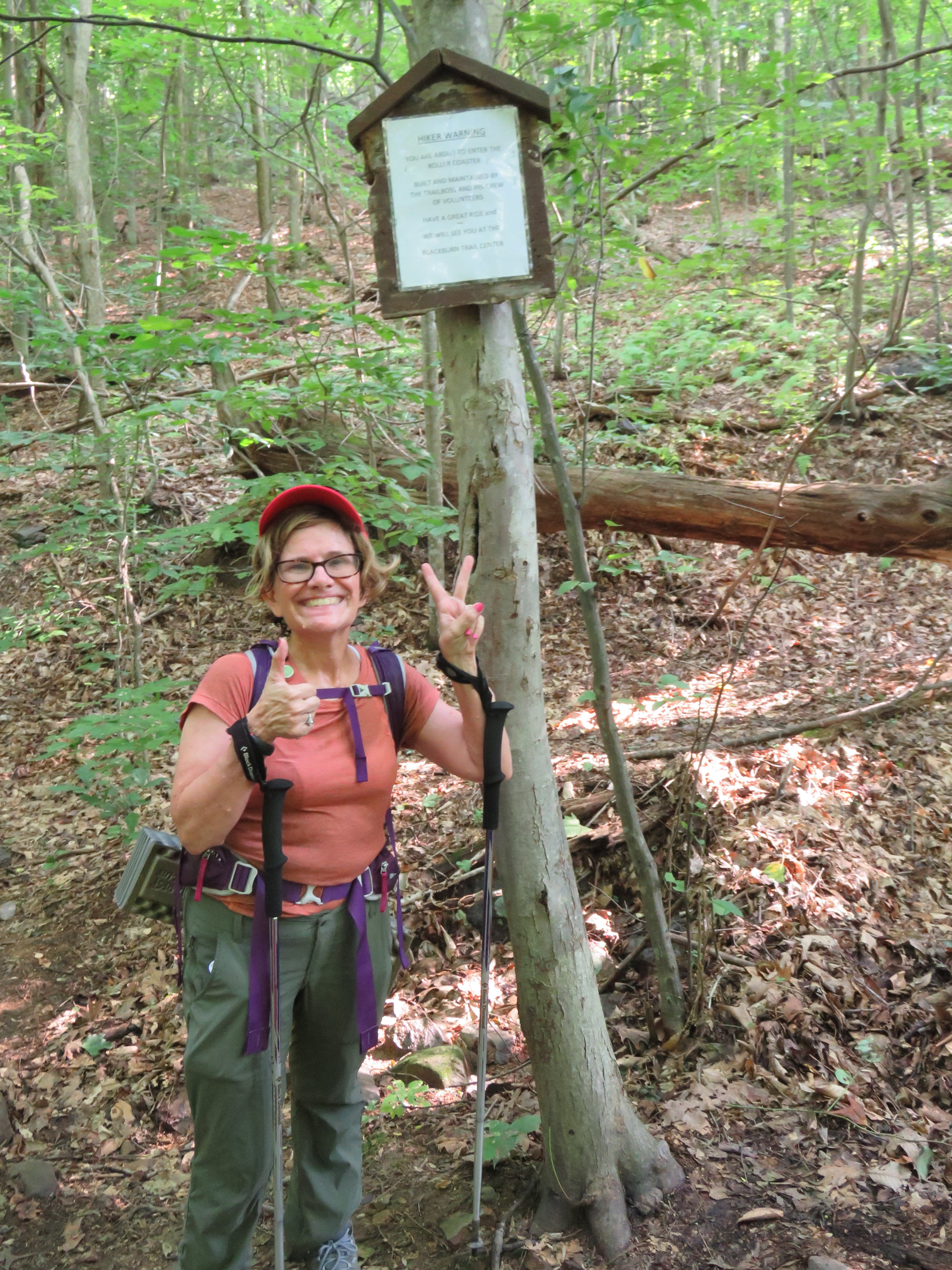
This section is known as the “roller coaster”. About a decade ago, the AT moved West onto a route that goes up and down, with 400-600 ft ascents and descents, one right after the other, for about 12 miles. Appropriately, it is known as “the roller coaster”. The hike began with a quick 400 ft. climb to Bear Dens Hostel. “Not bad!,” I thought. However, by the time we got to the beautiful area near Sam Moore Shelter, 3.5 miles later, we were shocked to find that we were going at about half our usual pace. At this rate, getting to our intended destination of Rod Hollow Shelter was looking pretty dim. Still, we pressed on, hopeful that we could pick up the pace.

Along the way we ran into a group of hikers who were attending the AT Conservancy conference. They would stop and we passed. When we stopped, they passed. Back and forth, we had opportunities to chat. (The next day, they took a day hike in the opposite direction and we saw them again!)

We used our water filter for the first time in a beautiful stream about a mile north of Rt. 605. Still, it was clear that we would need to stop for the night soon. We looked for a campsite that was supposedly just past Morgan Mill stream. No luck! We were headed up and up.

We never found the campsite. Tired, fried, whipped and beat, we reluctantly set up camp just off the trail near the top of Piney Ridge. I was convinced we were sitting on a bed of poison ivy! Although we had a delicious meal of mac and cheese ready to go, we soon realized that we had no utensils. Ugh! Have you ever eaten mac and cheese (and oatmeal the next morning) with just your fingers!?

Our "campsite"!

Our “campsite”!

The next day we took off determined to make up time and get to Dick’s Dome. After descending to Bolden Hollow there is a sharp turn right, up a hill to continue onto the AT. We didn’t see it! In fact, there is a white dash of paint on a tree near the turn that sort of suggests that one should continue straight instead of turn. (This is only a problem Southbound. North bound folks have a nice sign pointing to where to go. Please add one for those going Southbound!) We went off trail for quite a while before we realized our mistake and backtracked to get going in the right direction again.

We loaded up with tons of water (about 8 liters) at Rod Hollow. Although we had technically completed the roller coaster, the tremendous heat took its toll. The mud from the previous rains combined with the heat made it tough going. We were soaked with sweat and drinking water at a rate that was not sustainable in order to get to the next water supply. Our pace was awful and safety concerns caused us to make the decision to save the rest of the trip for a cooler day.

Yay! No more roller coaster!

Yay! No more roller coaster!

Luckily, we met a couple as we approached Ashby Gap that was willing to drive us to our car. All said, we learned some valuable lessons. Look at the elevation changes when planning trips, bring tons of food for energy, keep in mind trail conditions, and don’t plan tough hikes for 90+ day heat. Most importantly, when it stops being fun or health concerns kick in, take a break!


Appalachian Trail: Pine Grove Furnace State Park to PA-94.

Yesterday, Karen and I, having a common day off from work, decided to take the hour-and-a-half drive to advance the northern boundary of our A.T. experience. We started out where we had left off, at the Appalachian Trail Museum in Pine Grove Furnace SP. We had already toured the museum, which is predominantly a tribute to the earliest thru-hikers and the “firsts” of the A.T.

2015-07-10 10.04.012015-07-10 10.15.20

There, at the museum, the trail begins. It’s wide and smooth for the first quarter mile. It comes to a swimming pond, then parallels a stream. Then, it verges to the right and upward, where nature has carved for herself a run-off for water. Hardly have you begun than you spot a trail into the forest leading off to your left. It looks more like the typical A.T., and it’s evidently been used frequently—but, if you take it, you’ll see none of the usual white markers. It’s not the A.T. Stay with what looks like a gulley. When the A.T. does, eventually, diverge to the left, there will be signs. Many thanks to the A.T. clubs that maintain the trail and paint the swatches of white on the trees, rocks, and other permanent entities! Without those white markers, Karen and I would have been lost a dozen times thus far. Even when we are not lost, they are a comfort and assurance.

It had rained during the night, and the ground was often muddy. The vegetation was still wet, and the wetness contributed to the appearance of lush greenery. Much wetness had given rise to mushrooms of all sorts and other fungi. Karen took pictures. In fact, we both enjoyed having along our new camera. Perhaps, you will notice the added clarity in the photos.

Our trek was moderately rocky, for the most part. There were, as usual, the areas where the trail was nothing but rock upon rock, but these areas were the the exception. Most notable was the absence of physical landmarks. Karen and I had no luck in placing our position on the PATC map until we arrived at the turn-off to the James Fry Shelter. This was 7.5 miles into our 11 mile hike. Shortly afterwards, we crossed a bridge over a creek—our second creek crossing, so far, on this trip (counting the stream at Pine Grove Furnace SP as our first).

2015-07-10 13.43.46

Along our way, we ran into only two other hikers. One was traveling southward, from Allentown, PA, to Harper’s Ferry, WV. He was a white-bearded man who, in addition to much other talk, complained of having had nothing to eat for a day. We were happy to give him the joyful news that he was only a mile from the General Store at Pine Grove Furnace SP. The other fellow was a young and skinny speed-walker, with the most misshapen backpack, who caught up to Karen and me. He was on a mission: to arrive at Duncannon the following day; and, he said, he would hike throughout the night to do so. Was it only talk? Karen and I hoped so. After all, one has to look at where one places one’s feet; otherwise, one is likely to twist an ankle or worse—and then, what is one to do but take a forced rest. No, we were not impressed. We wished the fellow well and hope that he arrives at Duncannon without, first, making a wreck of himself.

2015-07-10 13.58.56

With this hike, Karen and I saw the last bit of the beautiful Michaux State Forest, which we had entered at Caledonia. After making it up and around Trent’s Hill, we crossed PA-94 and made it back to our car, which we had left on Sheet Iron Roof Road. Only two or three cars might park there, where the trail crosses the road, and I wouldn’t feel comfortable leaving my car there overnight. But, for a five-hour day hike, it proved to be a good enough parking spot.