Appalachian Trail: Shippensburg Road to Pine Grove Furnace State Park

After a great time in Shenandoah National Park, we longed to knock off a few miles on the AT. The problem? Finding time to squeeze it in given our work schedules. We decided to do a short overnight hike of 8+ miles.

A smooth trail!

A smooth trail!

Only 8 miles?!? Sometimes you’ve got to take what you can get. We started off Sunday evening at Shippensburg Road and found a wide, gentle path ahead of us. This was an ideal path that descended gradually. After about 1.5 miles we came to the turn off for the Michener Memorial Cabin. Now, the trail turned into the woods and a more traditional woodsy hike ensued. Mountain laurel were in bloom and they blanketed the entire forest. How beautiful!

We crossed a small stream, then walked a short way before a small bridge led us to Tom’s Run Shelter. A couple of years ago, one of two shelters burned to the ground. Now, a nice covered picnic area takes its place. This shelter has tons of tent pads and picnic tables. The privy, however, is among the worst yet. (You really don’t want the details!)

Our tent site. Pretty sweet, right?

Our tent site. Pretty sweet, right?

The best thing about the shelter was that a wonderful group of folks were staying there. There were two “old guys” (their term, not mine) who are brothers doing bits of the trail each year. “Shortbus”, a through hiker, and “Hendo” and “Hendo’s mom” were also staying overnight. A father/daughter team and a couple of other through hikers were there.

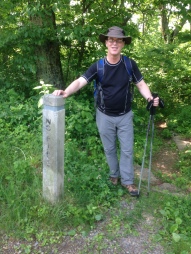
For the first time, we experienced a pretty significant thunderstorm overnight. It was still raining in the morning but that didn’t deter us a bit. We got a later start than everyone else but we quickly came to the AT halfway point (see picture).IMG_3858 Eventually we made it to the State Park’s General Store, where we met up with all our new friends from the shelter. Many ate the traditional half-gallon of ice cream, which is what the store is known for. Others opted for hamburgers. It was just nice to hang out and chat about the trail and about hiking. It was tough to leave the trail for home but it is good to know that even short hikes can be enormously enjoyable.
Hanging out at the General Store.

Hanging out at the General Store.

Corbin Cabin and Nicholson Hollow Loop

On June 11, our second hiking day at Shanandoah National Park, Karen and I decided to hike the Corbin Cabin Cutoff Trail to the eponymous relic, now maintained by the PATC, and from there take the Nicholson Hollow Trail back up to Skyline Drive, cross over to the Appalachian Trail, and take that north to return to the parking lot at mile 37.9. The entire trek would take us only 4.2 miles. Trail Head Compared to the Doyle Falls Trail, the Corbin Cabin Cutoff Trail is not as well defined. There were patches of grass growing on the narrow trail, which told us immediately that we were not on one of the more popular paths. In fact, we saw no one on our way down to the cabin. The first quarter mile of the trail is enclosed on both sides by white-flowered bushes. Further down, we encountered a black snake on the path. Black Snake Upon crossing Hughes River–which, I should add, is easily done, as there are large stones marking a path across what is really only a ravine–one immediately comes upon the log cabin built by George Corbin in 1909. It was locked up, but some bees appeared to have made a home in the roof. Karen and I had our lunch sitting on the front porch. Hughes RiverCorbin Cabin We had hardly begun our trek again when we spied the John T. Nicholson cabin on the opposite side of Hughes River. In Nicholson Hollow, before we began our ascent, we also caught sight of a large owl flying from one tree to another. Perched again upon a limb, it looked back at us, and then flew further on. Once we began our ascent, our movement frightened off a black bear, which scampered up the hill, away from us. All in all, it proved to be a great hike for spotting wildlife, as well as getting a little exercise. In the Falcon Guide to Hiking Shenandoah, the difficulty level of this hike is rated as moderate to strenuous.

Shenandoah National Park: Doyles River Falls and Jones Run

It has been too long since we’ve hiked the Shenandoah. Tod and I took the opportunity to camp in Big Meadows for a few days and enjoy getting out in the woods. I’m a big fan of water falls, so choosing the Doyles River Falls hike was perfect.

At the trailhead to Doyles River Falls

At the trailhead to Doyles River Falls

What immediately hit me as we descended down the trail was just how beautiful the trails are here in the Shenandoah. After recent hikes  on the AT in Pennsylvania, it was so refreshing to have wide, relatively smooth paths. The trail descends very quickly, from just under 3000 feet to close to 1400 feet in elevation. As we went, the trail soon “hugged” a river. I was so excited to see the first waterfall! I took a picture but the truth is that there were many more spectacular falls to come.

My favorite was one of the first falls (see the photo of Tod). It isn’t as big as some of the others, but the setting is so tranquil! The sound of the rushing water is mesmerizing. I sometimes wonder how folks can some to this park and only go to the overlooks. Boy, are they missing some thing!

IMG_3803


For a while we were lucky to have a very easy go of it. However, it wasn’t long before the trail joined at Jones Run Trail. We crossed Jones Run (a pretty small stream, really) then began a long, steep ascent. This was, by far, the toughest part of the hike. According to our guidebook, we knew we would soon reach Jones Run Falls. This was our motivation.

Jones Run Falls was the perfect end to a mile-long trek up the trail. We were not disappointed! Large, smooth boulders afforded the perfect spot for lunch. This area is pretty secluded. We only saw one other couple there.

From here, we enjoyed a more gentle ascent. The woods were so beautiful! It wasn’t long before we were back up to Skyline Drive and we turned right onto the AT. As is typical of the AT, the trail narrowed. In fact, there was one spot where it was completely blocked by a downed bush and tree. For the most part, the AT follows Skyline Drive. However, it is far enough way from the road to give one the feel of being far removed from traffic.

Hiking can be a perfect way to clear one’s head, forget everyday life, and zone out. Why not just relax?!? This hike was another reminder that attentiveness is always important in

A very BIG rattle snake!

A very BIG rattle snake!

the wild. All of a sudden I came across a very lively rattle snake poised on the trail! I stopped, backed away, and ran right into Tod (who always follows behind me). As you can see by the picture, this guy was strategically located. No way we could stay on the trail! We carefully went up into the thicket far above the snake and bypassed the danger. From here, I was much more vigilant.

There are quite a few options to leave the trail at this point. One can go to Dundo Picnic area or Browns Gap, for example. We continued on and were soon back at the Doyles River Falls trailhead. Another wonderful hike that we can check off our list!

Rocky Mountain National Park: Estes Cone

One motto all backpackers and hikers must have? “Never pass up an opportunity to visit a national park!” After attending a professional conference in Denver, I couldn’t resist the chance to hike in the Rockies.

There were so many trails to choose from that it took me days to settle on Estes Cone. Why Estes Cone? The Cone is a moderate hike with excellent views and the chance to arrive at a summit. As important, it was accessible (just moderate snow) and trails hadn’t been wiped out by flooding, etc. (as is the case in some areas).

This time I was solo. I arrived at the Longs Peak trailhead to start my adventure, only to find that I was completely alone. Not a single car in the lot and no park rangers! The trailhead is not well marked so I had no idea where to begin. (I found a trailhead but wasn’t sure if it was the right one.) Just then, two young women came from out of nowhere carrying coffee mugs. They were on a short morning walk from their camping area. Voila! I was guided to the right spot and started hiking.

Estes Cone in the background.

Estes Cone in the background.

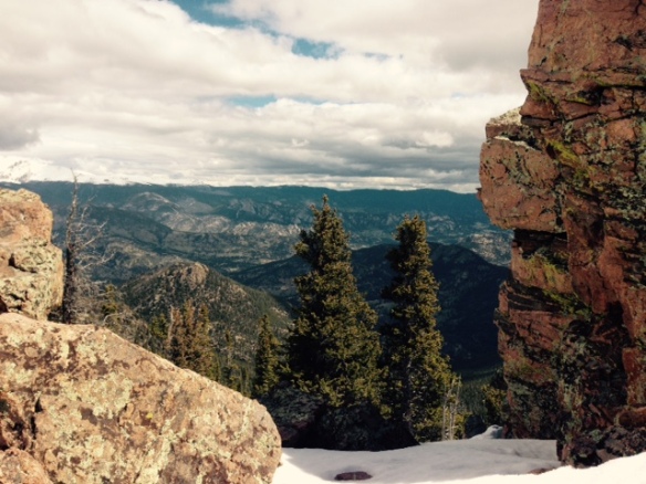
The trail begins around 9,400 feet and ascends slowly. I was among beautiful pines and loved hearing the tweets of nearby birds. The sounds of spring, combined with cool weather and a snowy trail, was an interesting contrast. I ended up putting my crampons on for a short while.  Every once in a while I got a view of my ultimate destination. It seemed pretty daunting!

Eventually, the trail comes to a bridge made of a half-log that crosses a beautiful stream. At Eugenia Mine (according to a sign it produced more dreams than gold) the trail turns to the right. After many ups and downs, the trail comes to a field. As I stopped to take a break, another couple passed me. “You must be the person who owns the other car in the lot!” they said. They were seasoned high altitude hikers so they moved faster than me. The trail goes up and down, until it eventually came to the .7 mile steep ascent to the top.


FullSizeRender (2)
Apparently, the Rocky Mountain National Park doesn’t believe in using tree markers to delineate trails. No white or blue blazes to follow! Instead, a series of cairns guided me as a steadily made my way up. In the dense trees, I had no idea how close I was to the top. As I got higher, however, the “trail” became more and more rocky, with more and more snow. At the advice of the couple who had passed me and now were on the way down, I put my crampons back on.

The summit, at just over 11,000 ft.,  was completely worth it! Although the weather threatened all day, it was still a spectacular view. Although windy and cold, I enjoyed a delicious sandwich at the top, and much to the dismay of a nearby chipmunk, I ate the whole thing.

FullSizeRender (3)Descending wasn’t too difficult, but I did need tp pay close attention that I didn’t leave the trail. The ice and snow made walking tricky, so I tried to take my time. At one outlook area, I stopped to eat more snacks. I didn’t want to leave! Instead, I tried to savor my time on the trail.

All things must come to an end. As I left the trail, I met a park ranger who said he is moving to Gaithersburg, Maryland (my hometown) in the next few months. How about that!?! All in all, I can’t wait to come back to the Rockies and try an even more ambitious hike. I’m ready!FullSizeRender (4)FullSizeRender (1)